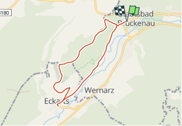
![](/images/other/stat-length.png)
![Excursión A pie Bad Brückenau - Rhön-Rundweg 5 Sinntal - Photo](https://media.geolcdn.com/t/1900/400/512cb942-2099-4270-9c1c-ace978edfe38.jpeg&format=pjpeg&maxdim=2)
Rhön-Rundweg 5 Sinntal
SityTrail - itinéraires balisés pédestres
Tous les sentiers balisés d’Europe GUIDE+
![Longitud](/images/other/stat-length.png)
![Altitud máxima](https://static1.geolcdn.com/siteimages/upload/files/1508320355ic_sort_altitude_max_24dp.png)
![Desnivel positivo](https://static1.geolcdn.com/siteimages/upload/files/1508320355ic_sort_den_pos_24dp.png)
![Km-Effort](/images/other/stat-length.png)
![Altitud mínima](https://static1.geolcdn.com/siteimages/upload/files/1508320355ic_sort_altitude_min_24dp.png)
![Desnivel negativo](https://static1.geolcdn.com/siteimages/upload/files/1508320355ic_sort_den_neg_24dp.png)
![Boucle](https://static1.geolcdn.com/siteimages/upload/files/16400158638029165_repeat_loop_refresh_sync_direction_icon.png)
![A pie](https://static1.geolcdn.com/sitytour/trail-icons/100.png)
2h10
Dificultad : Fácil
![Escanee este código QR para abrir la excursión en la aplicación SityTrail](https://capi.geolives.com/qq0zvz2zws4bq2lad0pu/sitytour/trails/3092068/qr.png?size=200)
Aplicación GPS de excursión GRATIS
A propósito
Ruta A pie de 6,9 km a descubrir en Baviera, Landkreis Bad Kissingen, Bad Brückenau. Esta ruta ha sido propuesta por SityTrail - itinéraires balisés pédestres.
Descripción
Symbol: Weiße 5 auf blauem Hintergrund
Sitio web: https://www.bad-brueckenau.de/de/index.cfm?fuseaction=gaeste&rubrik=wandern#/de/bad-brueckenau/default/detail/Tour/B4ED78C972E20D629054F29D3ED68C6F/fondsbergweg-5
Localización
Comentarios
Excursiones cerca
![Excursión A pie Sinntal - Oberzell - Rundwanderweg Hemmersbach - Photo](https://media.geolcdn.com/t/375/260/4e962bfc-8421-43f7-8dea-a30191c785e8.jpeg&format=jpg&maxdim=2)
![A pie A pie](https://static1.geolcdn.com/sitytour/trail-icons/100.png)
A pie
![](/images/other/stat-length.png)
![](https://static1.geolcdn.com/siteimages/upload/files/16400158638029165_repeat_loop_refresh_sync_direction_icon.png)
![Excursión A pie Sinntal - Spessartspuren - Schwarzenfelser Sonnenseite - Photo](https://media.geolcdn.com/t/375/260/2a05401e-dc40-44c1-afe1-0448727b6160.jpeg&format=jpg&maxdim=2)
![A pie A pie](https://static1.geolcdn.com/sitytour/trail-icons/100.png)
A pie
![](/images/other/stat-length.png)
![](https://static1.geolcdn.com/siteimages/upload/files/16400158638029165_repeat_loop_refresh_sync_direction_icon.png)
![Excursión A pie Sinntal - Oberzell - Rundwanderweg Sandberg - Photo](https://media.geolcdn.com/t/375/260/4e962bfc-8421-43f7-8dea-a30191c785e8.jpeg&format=jpg&maxdim=2)
![A pie A pie](https://static1.geolcdn.com/sitytour/trail-icons/100.png)
A pie
![](/images/other/stat-length.png)
![](https://static1.geolcdn.com/siteimages/upload/files/16400158638029165_repeat_loop_refresh_sync_direction_icon.png)
![Excursión A pie Sinntal - Oberzell - Rundwanderweg Sinngrund - Photo](https://media.geolcdn.com/t/375/260/4e962bfc-8421-43f7-8dea-a30191c785e8.jpeg&format=jpg&maxdim=2)
![A pie A pie](https://static1.geolcdn.com/sitytour/trail-icons/100.png)
A pie
![](/images/other/stat-length.png)
![](https://static1.geolcdn.com/siteimages/upload/files/16400158638029165_repeat_loop_refresh_sync_direction_icon.png)
![Excursión A pie Sinntal - Oberzell - Rundwanderweg Haag - Photo](https://media.geolcdn.com/t/375/260/4e962bfc-8421-43f7-8dea-a30191c785e8.jpeg&format=jpg&maxdim=2)
![A pie A pie](https://static1.geolcdn.com/sitytour/trail-icons/100.png)
A pie
![](/images/other/stat-length.png)
![](https://static1.geolcdn.com/siteimages/upload/files/16400158638029165_repeat_loop_refresh_sync_direction_icon.png)
![Excursión A pie Sinntal - Ulrich von Hutten Pfad - Photo](https://media.geolcdn.com/t/375/260/5b879310-8a98-493b-9adc-0b7d48451c38.jpeg&format=jpg&maxdim=2)
![A pie A pie](https://static1.geolcdn.com/sitytour/trail-icons/100.png)
A pie
![](/images/other/stat-length.png)
![](https://static1.geolcdn.com/siteimages/upload/files/16400158638029165_repeat_loop_refresh_sync_direction_icon.png)
![Excursión A pie Sinntal - Oberzell - Rundwanderweg Hirschberg - Photo](https://media.geolcdn.com/t/375/260/4e962bfc-8421-43f7-8dea-a30191c785e8.jpeg&format=jpg&maxdim=2)
![A pie A pie](https://static1.geolcdn.com/sitytour/trail-icons/100.png)
A pie
![](/images/other/stat-length.png)
![](https://static1.geolcdn.com/siteimages/upload/files/16400158638029165_repeat_loop_refresh_sync_direction_icon.png)
![Excursión A pie Bad Brückenau - Rundweg Sinntal 14 - Photo](https://media.geolcdn.com/t/375/260/ext.jpg?maxdim=2&url=https%3A%2F%2Fstatic1.geolcdn.com%2Fsiteimages%2Fupload%2Ffiles%2F1545311037marcheuse_200dpi.jpg)
![A pie A pie](https://static1.geolcdn.com/sitytour/trail-icons/100.png)
A pie
![](/images/other/stat-length.png)
![](https://static1.geolcdn.com/siteimages/upload/files/16400158638029165_repeat_loop_refresh_sync_direction_icon.png)